Bear with me. This is going to be loquacious and involve mentally compositing two topo pics and one satellite. Don't be scared yet, it's not even 400 acres. What could go wrong?
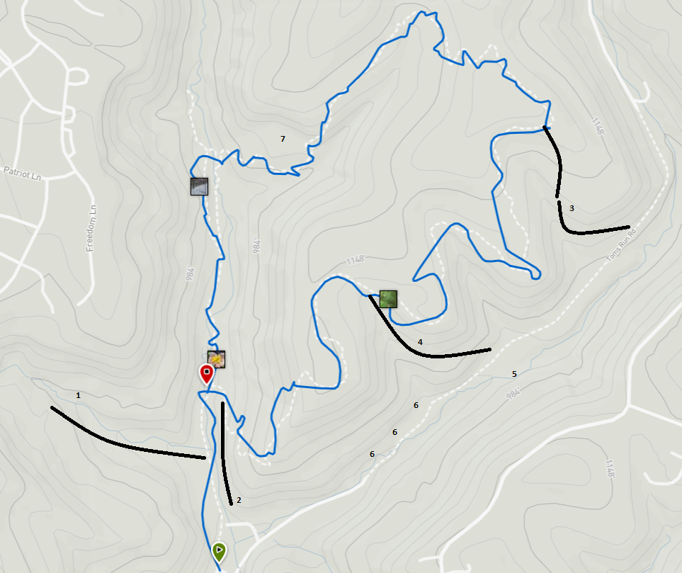
Let's look at and talk about this one first, shall we?
1. This is a pretty neat rock outcropping. The curved line (conveniently approximated on the second map also)
follows the stream that's worth noting. This is the first small crossing headed in from the parking lot on what was once Dogwood Lane. The stream bifurcates and is
easier to cross in some places than others. Sometimes the leftmost runs full and the right is dry, sometimes otherwise. Water... how does it work?
One side kinda pops up outta the ground from nowhere. Again, water... how does it work? Walking up the near side you can explore the stream
and get a decent view of the rocks, walking up the far side is a level 2 sketch (on a scale of 10) climb up a hill. Def worth checking out both ways.
2. There's an old Jeep trail that runs parallel to Dogwood Lane on the other side of the creek. If you start up the trail CCW you hit two
sets of steps. Take the second and bear off to your right. Cross big log... scamper 'round bog... 🎵 and keep going. My favorite hammocking
spot is down here. Shhh... don't blow up the spot. When you wind up back at parking lot level there's not much to see. Do keep an eye out to your left and you'll
find a pile of brick near an old water well. If you like piles of garbage
this isn't a bad place to explore. The conservancy took a few houses down here when they acquired the property. It shows in spots. Like the water well.
3. This is probably my favorite excursion old dirt bike trail leading from the clearing to the Kennel
side of Tom's Run Road. Sketch level 4 for shitty footing and kinda steep for a bit. Detail 10 on the satellite map shows where the
trail crosses a clearing. When you hit that in the CCW direction at about mile 2 pop up out of the woods and you can
see where this heads down the hill to your right. It's kinda blocked kinda, don't let that dissuade you. Fun time. And for bonus
points, if you scurry about down here enough you may pop up into the plot that the conservancy doesn't own with a transmission tower on it.
The PDF map from the conservancy's web site shows that well and there's a really boss video of me stumbling on the tower on my Instagram.
Well, it was fun for me anyhow.
4. The old gas well access road crosses the trail here and heads down to the vacated portion of Tom's Run Road. We're gonna call that TRR from
here on out, k? When the well was plugged
a few years ago Andy from the Conservancy asked the crew to blocade the road on their way out to keep dirt bikes and quads out.
They did well at that as well as creating some gnarly obstacles to get around trying to hike it. I've gone over the piles, cautiously and slowly
and it's generally NBD. But if you're not comforatble with it don't fuck around and find out. It'd be a shitty placeto get out of with
a broken leg.
5. At the bottom of the hill old TRR kinda stays uphill and there's a path that splits off to the right and meanders into a
little bit of a valley. There's a little stream to cross here, but there's a little fen I like really well tucked in here. No obstacles,
nothing super scenic, just a fun spot to kick back and have a PB&J.
6. The last time I was here it was already pretty overgrown and brushy to navigate but there's a long string of old power poles and lines
that are down just above the ground. I found it exciting in the way that a child may find a grasshopper exciting.
7. Plugged Well. It's pretty wild how well this is growing in after a few years. Just NE of the "7" (to it's right on the map) the trail
follows the other side of the access road. The pad itself is surrounded by more stacks of tree trunks but I think it's fairly obvious
to find an accessible. In the dead center of the clearing is a steel pole with a steel plate weled to it with the well ID numbers written on it
in more booger welds. It's worth exploring along the back side of the old well opposite the train IMO. I followed a rill nice
game trail around the hill there once... wound up off of conservancy property... happens.
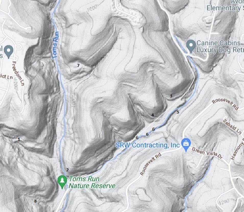
Okay, next map. Same approximate area, most numbers I've tried to overlap as closely as possible but we do have
one unique entry here.
8. I really like this corner (bottom left, eh?) to the left of the parking lot. There's not much to see, it's usually a bit muddy, there's some trash around...
oh... that' why I like it. Kinda like me. Flawed but charming. I don't collect nearly the amount of trash that this spot has though for sure. No
tree stands in my area. It seems like this was one of the more popular hunting spots, it sounds like the whole area has been less and less fruitful
in recent years since the trail went in. Not far off the parking lot there's what looks like another old oil well casing that's capped off.
speculation is that there could be a half dozen more out here that nobody knows about.
This map shows the access road a lot better at points 4 and 7. Countours. I do know how they work.
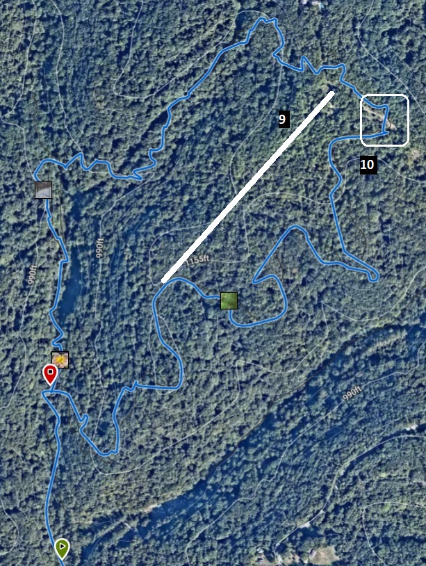
Satellite time.
This shot and the first map are from my entry for the trail on The Hiking Project btw so I could overlay the
trail for some sense of orientation.
9. I've only walked the ridge line once and it's brushy as hell but I like it a lot. At one point in the trail (CCW) you'll look straight and
see where it goes. It doesn't look promising with a ton of trees down, the trail legit turns downhill to the right. If I ever think about getting a
good shot of what I'm talking about I'll add it here. The northern end terminates at the access road where it hooks up to the clearing so
when you're familiar with the trail in that area you're golden to find your way. I've squelched my urge to moon the game cameras I came across
here. Somehow.
10 is the inset I mentioned earlier to illustrate where to find my fav dirt bike trail off of the clearing. I never said this was going
to be easy to follow, did I?
Now, I haven't even mentioned the smaller, discontiguous section of the preserve on the other side of TRR just off of
Rte. 65 and Roosevelt road. For shame. The map from the conservancy shows where it is, totally worth exploring, lots
of side trails and old dirt bike trails so check back for more updates here in the next 5 or 6 years on that. The picture on my home page is
fron that plot looking down the power line cut over the Ohio. It makes me happy
like much of the exploring on either side of the hill.